Geography


Manipur is one of the seven states of Northeast India, and one of the Seven Sister States. The state is bounded by Nagaland in the north, by Mizoram in the south, by Assam in the west, and by the borders of the country Myanmar in the east as well as in the south. The state capital of Manipur is Imphal. The state lies at latitude of 23°83’N – 25°68’N and longitude of 93°03’E – 94°78’E. The total area covered by the state is 22,347 km². The capital lies in an oval-shaped valley of approximately 700 square miles (2,000 km2) surrounded by blue mountains and is at an elevation of 790 metres above the sea level. The slope of the valley is from north to south. The presence of the mountain ranges not only prevents the cold winds from the north from reaching the valley but also acts as a barrier to the cyclonic storms originating from the Bay of Bengal.
There are four major river basins in Manipur State, the Barak River Basin (Barak Valley) to the west, the Manipur River Basin in central Manipur, the Yu River Basin in the east, and a portion of the Lanye River Basin in the north. The total water resources of Barak and Manipur river basins are about 1.8487 Mham. The overall water balance of the state amounts to 0.7236 Mham in the annual water budget. (By way of comparison, India receives 400 Mham (million hectare meters) of rain annually) TheBarak river, the largest river of Manipur, originates in the Manipur Hills and is joined by a number of tributaries such as the Irang, Maku, and Tuivai. After its junction with the Tuivai, the Barak River turns north and forms the border with Assam State, and then enters the Cachar Assam just above Lakhipur. The Manipur river basin has eight major rivers: the Manipur, Imphal, Iril, Nambul, Sekmai, Chakpi, Thoubal and Khuga. All these rivers originate from the surrounding hills.
Almost all the rivers in the valley area are in the mature stage and, therefore, deposit their sediment load in the Loktak lake. The rivers draining the Manipur Hills are comparatively young, due to the hilly terrain through which they flow. These rivers are corrosive in nature and assume turbulent form in the rainy season. Important rivers draining the western area include the Maku, Barak, Jiri, Irang and Leimatak. Rivers draining the eastern part of the state, the Yu River Basin, include the Chamu, Khunou and other short streams.
Physiographically, Manipur may be characterised in two distinct physical regions – an outlying area of rugged hills and narrow valleys, and the inner area of flat plain, with all associated land forms. These two areas are not only distinct in respect of physical features but are also conspicuous with regard to various flora and fauna. The valley region would have been a monotonous, featureless plain but for a number of hills and mounds rising above the flat surface. The Loktak lake is an important feature of the central plain. The total area occupied by all the lakes is about 600 km². The altitude ranges from 40 m at Jiribam to 2,994 m at Mt. Iso Peak near Mao Songsong.
The soil cover can be divided into two broad types, viz. the red ferruginous soil in the hill area and the alluvium in the valley. The valley soils generally contain loam, small rock fragments, sand and sandy clay, and are quite varied. On the plains, especially flood plains and deltas, the soil is quite thick. The top soil on the steep slopes is very thin. Soil on the steep hill slopes is subject to high erosion, resulting in gullies and barren rock slopes. The normal pH value ranges from 5.4 to 6.8. The climate of the State is salubrious with approximate average annual rainfall varying from 933 mm at Imphal to 2593 mm at Tamenglong. The temperature ranges from sub-zero to 36°C.
Districts
Manipur has currently nine administrative districts.
District | Area | Population | Headquarters |
|---|---|---|---|
| Bishnupur | 496 | 208,368 | Bishnupur |
| Churachandpur | 4570 | 227,905 | Churachandpur |
| Chandel | 3313 | 118,327 | Chandel |
| Imphal East | 709 | 394,876 | Porompat |
| Imphal West | 519 | 444,382 | Lamphelpat |
| Senapati | 3271 | 283,621 | Senapati |
| Tamenglong | 4391 | 111,499 | Tamenglong |
| Thoubal | 514 | 364,140 | Thoubal |
| Ukhrul | 4544 | 140,778 | Ukhrul |
Vegetation
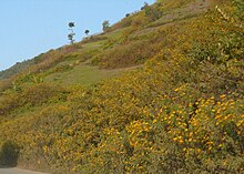
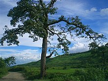
The natural vegetation occupies an area of about 14,365 km² which is nearly 64% of the total geographical area of the state. The vegetation consists of a large variety of plants ranging from short and tall grasses, reeds and bamboos to trees of various species. Broadly, there are four types of forests:
- Tropical Semi-evergreen.
- Dry Temperate Forest
- Sub-Tropical Pine
- Tropical Moist Deciduous
Teak, pine, oak, uningthou, leihao, bamboo, cane, etc. are important forest resources growing in plenty. In addition, rubber, tea,coffee, orange, and cardamom are grown in hill areas. Rice is a staple food for Manipuris. Rice and cash crops make up the main vegetation cover in the valley.
Climate


The climate of Manipur is largely influenced by the topography of this hilly region which defines the geography of Manipur. Lying 790 meters above sea level, Manipur is wedged between hills on all sides. This northeastern corner of India enjoys a generally amiable climate, though the winters can be a little chilly. The maximum temperature in the summer months is 32 degree C. In winter the temperature often falls below zero, bringing frost. Snow sometimes falls in some hilly regions due to the Western Disturbance. The coldest month is January, and the warmest July. The ideal time for tourism in the state, in terms of climate, is from October to February, when the weather remains bright and sunny without the sun being too hot.
The state is drenched in rains from May until mid-October. It receives an average annual rainfall of 1467.5 mm. However, the rain distribution varies from 933 mm in Imphal to 2593 mm in Tamenglong. The precipitation ranges from light drizzles to heavy downpour. The normal rainfall of Manipur enriches the soil and helps in agricultural processes and irrigation. The South WesterlyMonsoon picks up moisture from the Bay of Bengal and heads toward Manipur, hits the eastern Himalaya ranges and produces a massive amount of rain in the state.
No comments:
Post a Comment